

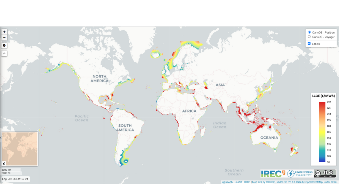

The Catalonia Institute for Energy Research (IREC) has designed a tool that allows the creation of a global map of floating offshore wind systems, including the associated development costs of these parks, and highlights the most suitable areas.
José Luis Domínguez, head of the Power Systems group at IREC, explained that the offshore wind sector, particularly floating wind, “is growing and is practically the only feasible solution for Mediterranean countries and other areas with great depths, where fixed systems are not possible.”
Therefore, the objective of this map is to demonstrate the viability and areas of interest for current installation through a “basic guide for identification”.
In its development, variable cost factors have been considered based on bathymetry, ocean conditions, distance to the coast, and distance to port. Power delivery performance calculations have been used as a reference for energy output, rather than turbine production.
José I. Rapha, a floating offshore wind researcher at IREC and one of the project participants, commented that the level of detail is complex, as they utilize databases of all the ports worldwide, and the analysis extends up to 400 kilometers from the coast and depths ranging from 60 to 1000 meters of water, with a resolution of one arc minute.
“It has a fairly good precision,” Rapha stated in an interview with the EFE Agency, adding that thanks to this map, “it is very easy to see where a farm for this type of wind energy can be installed.”
Regarding Levelized Cost of Energy (LCOE) values, average results for different floating concepts supporting a 15 MW turbine in a 300 MW wind farm are represented, identifying many areas with costs below €100/MWh.
During its development, Rapha explained that a team with diverse backgrounds participated, “where sometimes the same person can have two roles at the same time,” involving different areas such as programming, map design, website development, data collection, and management, among others.
Currently, this map is available for consultation under an open license on the website floatingwindmap.energysmartlab.com, although the organization has emphasized that commercial use is restricted. If a company is “interested in obtaining more information or specific details about a particular area,” they should contact them.
You can find the related press release from today: